
Abstract
There are multi-faceted, invisible layers within a writer that impact the writer’s processes. Since these layers are not necessarily brought to conscious awareness or made visible, however, the writing process contains unintentional influencers. I forward these notions to argue for intentional pedagogical practices that not only consider ideas of space, place, and land but practices that incorporate ways of visually depicting their relationships with literacy practices as well. There is, to my knowledge, little work exploring specific cartographic technologies as they might apply to pedagogical strategies in composition studies. Through an IRB-approved qualitative study, this project explores a nuanced understanding and application of mapping techniques as fruitful for composition assignments and composition research. Exploring the relationship between embodiment and literacy practices, I argue for a heightened awareness of the relationships between place/space and body/embodiment in effective writing pedagogy.
Keywords
Cartography, place, writerly identities, literacy practices, viewpoint maps, writing geographies
Writing is complex. Writing is social action. Writing as social action is a manifestation of the complex interactions and embodiments within a place; its processes are shaped by a writer’s lived experiences. These are not new statements to writing studies scholars, and they continue to strongly influence pedagogical approaches. In fact, for quite some time, writing instructors have explored the relationship between writing and place. As Marilyn Cooper explained in 1986, writing is not a simple action of communicating information; rather, it is a “social activit[y]” (366) through which context becomes an integral part of the composing process. It is an ecology. Embracing the ecosystem of writing means instructors seek to guide students in specific ways: 1) to realize the reciprocity of writing and place where writing both shapes and is shaped by place, and 2) to realize the authenticity of writing as it results from a connection between place and writing. When student-writing is characterized by this sense of writer authenticity, then students are exercising what composition scholar Ira Shor calls creative power (When Students Have Power) and what composition scholar Frank Farmer describes as “citizen bricoleurs” (21). They become, in other words, student-writers who realize the productive influence their writing might have on society.
The challenge for many writing instructors, myself included, is not that we do not understand writing and place as elements in an ecosystem. Rather, the challenge is to bring students to a heightened awareness of writing ecologies, thereby providing them skills through which they achieve a productive writerly identity capable of critical interrogation and affecting societal change. Attention to the reciprocity of place and writing allows us to consider unrealized, or invisible, experiences and interactions that provide meaning for place. Tim Cresswell in Place: An Introduction explains that these unrealized experiences and interactions include language practices, or subjects of conversations, religious practices, and so on—all occurring within a particular space. Therefore, to seek out the pedagogical benefits of fostering students’ critical awareness of the invisible layers of place informing their literacy acts, this essay is guided by the following questions: Given that place is characterized by invisible attributes that are potentially unrealized and unexamined, how might I guide my students to consider the invisible characteristics of place as a contextual attribute informing their writing? Further, how might a student-constructed visual representation of their layered, lived experiences raise a critical awareness of the ways spatial embodiment impacts literacy acts? How complex layers of place might be unintentional influencers?
While these questions are expansive and taken up in a larger scholarly discussion, it is my goal in this article to inspire writing teachers to design assignments and activities for their students that draw from the exciting possibilities that arise when we incorporate cartographic techniques within writing studies. While there is valuable discussion of place/space and writing processes (see Paul Prior and Jody Shipka’s essay where students map their writing places), my work differs from that scholarship because I am focused on providing students the opportunity to visualize and subsequently examine the out-of-class lived experiences informing their writerly identities as well as their writing processes. In short, this project focuses not on the literal place where students write but on visual representations of students’ layered lived experiences that inform writing practices. To help me address my specific questions, I draw from scholars whose work, to my understanding, conceptualizes writing, place, and identity in the same ways I am conceptualizing them. In this article, I weave together scholarship from writing studies, cultural geography, and cartography to investigate the relationship between embodiment and literacy practices and to argue for a heightened awareness of the relationships between place/space and body/embodiment in effective writing pedagogy. I first provide a brief scholarship overview of these three fields to contextualize a specific assignment. I then examine data from a semester class in which students engaged with the assignment. Finally, I explore the potential benefits of this type of assignment in writing pedagogy.
Drawing from classical rhetoric, there is a long tradition in writing studies of understanding place in relation to writers. For example, Plato’s Socrates in The Phaedrus, encourages his protégé to pause and reflect on place as an integral part of his thinking processes. Rhetors, according to Sharon Crowley and Debra Hawhee in Classical Rhetoric for the Contemporary Student, must attend to the importance of place as part of the rhetorical situation. Nedra Reynolds’ 2004 groundbreaking work with her students in Leeds brought attention to the connection between experiences within a place and how those sedimentary experiences shape students’ writing. Reynolds’ work is noteworthy primarily because the affect of place influences responses; and writing is a responsive act. In fact, Reynolds argues composing, for the most part, is “drawn from a store of remembered and well-rehearsed spatial practices that come from the everyday and become engrained, habitual, embodied” (2). Because these spatial experiences become “engrained, habitual, embodied,” they are what I identify here as invisible influences.
Similar to the interactions between biological organisms and their environments, writing as social action is complex and informed by everyday experiences and interactions in an ecological manner. In Marilyn Cooper’s 2010 chapter Being Linked to the Matrix: Biology, Technology, and Writing, she asserts there is a reciprocal relationship between embodied experiences and students’ literacy acts. Building on her 1986 argument that writing is a response involving body and mind, Cooper claims the response is “only partly and sometimes intentional” (15). Other writing scholars, such as Anne Wysocki, Julie Drew, and Hannah J. Rule, explore the ways a writer’s responses to social and physical environments arise from unconscious layers of interactions; there are multi-faceted, invisible layers within a writer that impact the writer’s processes. In other words, there are moments in the writing process, as a response to the complex interactions within a place, when there is an unintentionality to the response.
Accepting the significance of complex layers of place as unintentional influences on writing, then, allows writing instructors to think how they might raise students’ awareness of those invisible layers. Joddy Murray, professor and scholar of multimodal writing studies, explains that to raise awareness, we can encourage students to convert alphabetic-text communicative modes into “hybrid texts that incorporate many modes at once… [and thereby compose texts] that take advantage of image, emotion, and nonsequentiality” (2–3). According to Murray, non-discursive composition is useful for students because it strengthens the connections between image texts (non-discursive) and alphabetic texts (discursive texts) and provides opportunities for meaning to be deepened. Put another way, the non-discursive is a pathway to the discursive because “the central feature of language is image” (135). Jody Shipka, another multimodal scholar, explores in her seminal work Toward a Composition Made Whole, a broader understanding of multimodality and argues for an intentionality in employing all possible modes of writing. Yet another similar argument is made in Kristie S. Fleckenstein’s groundbreaking work Embodied Literacies, in which she merges image and word in a non-sequential, “inevitable linkage” (5) in meaning-making. Thus, when we want to more thoroughly understand our students’ literacy acts, and when we want our students to critically interrogate their literacy practices and habits, we can pursue communicative modes that combine image (non-discursive) and alphabetic (discursive) texts in meaningful ways.
Further, the shared experiences of those inhabiting the same space deepens place’s influence on a writer. If we agree with Michel de Certeau (on whose theory Reynolds grounds her above-mentioned work) that when experiences and information are shared among those inhabiting the same space, it means space becomes meaningful through the commonly-shared interactions between its inhabitants—it becomes common (xxii; 96). A space shapes lives and is shaped by those lives because there is a reciprocity between place and writing resulting from the complex layers of interactions within that space. Cultural geographer Tim Cresswell explains that through the relationship of experiences and place, “a meaningful location” (Place 12) is created. In other words, for Cresswell and for my purpose here, place is “how we make the world meaningful and the way we experience the world” (Place 19). For Cresswell, realizing the shared experiences “makes us more aware of ourselves, of the world, and of our relationship with the world” (Geographic Thought 3). Place is meaningful because it is “part of the way we see, research, and write” (Place 24). I take up Cresswell’s definition for “place” and agree with Reynolds that place becomes an important aspect of writing and thinking. Thus, the challenge previously mentioned is to seek a useful pedagogical strategy that guides students’ heightened awareness of the connections between place and literacy.
To address that challenge, I suggest we borrow a useful method for visually representing activity in and through space from the field of cartography. Maps are commonly used to visually depict movement through space and among places. Travelers use road maps (both paper and digital) to plan vacations and to calculate distances between points of interest, among other things. Admittedly, mapping technologies have historically been associated with demarcating borders and boundaries and even legitimations of power structures, but there is also robust scholarship exploring ways maps have been used to depict abstract spaces: cognitive mapping (Hirschfeld & Gelman), curriculum mapping (Jacobs), and concept maps (Villalen & Calvo), to name a few. Perhaps not so common, however, is to consider maps as social constructs. Maps provide a visualization of the complex layers of information and symbolize social structures informing place. Cartographic scholars Denis Wood and John Short explore, analyze, and critique cartographic symbols, language, and development. Through their various works, they explain the development of a common mapping language in the form of line variations and shapes that communicate the same meaning regardless of the map style. Central to my argument here is one particular cartographic construct, namely pictorial mapping, sometimes called viewpoint mapping. These maps foreground cultural/social relationships by combining cartographic symbolization with artistic expression to provide nuanced understandings of a specific place. These are important characteristics of mapping technology because the affordances of visuals and symbols allow us to convey multiple layers of information beyond the constraints of linearly-constructed compositions.
To summarize, individual identities and person-to-person or person-to-place relationships are determined by spatial interactions (de Certeau; Reynolds) and by forces not always fully controlled by the writer (Rule). To think of writing practices as spatial rather than temporal allows us to better understand the unintentional influencers on writing processes and writerly identities. Since the layers are not necessarily brought to conscious awareness or made visible, though, they remain unexamined. This lack of examination hinders a writer’s critical inner reflection—which, as writing instructors know, is an important step in the writing process. My aim here is to argue that a spatial understanding of the writing process allows us to pursue intentional pedagogical practices that not only consider ideas of space, place, and land, but incorporate ways of visually depicting their relationships with literacy practices as well. Extending these notions into writing studies means writing instructors must consider the ways space influences meaning-making, i.e., learning, reading, and writing (Reynolds; Rule; Shipka), and thereby not only recognize the complex layers, but also interrogate them.
Therefore, for writing to be a meaningful expression, we must explore strategies for a writing pedagogy that increases students’ awareness of place as an unintentional influence on literacy practices and identities. This project builds on Reynolds’ robust exploration of ways inhabited places influence writing and extends her analysis to examine the opportunities writing instructors have to foster students’ critical awareness of ways their embodied experiences influence their literacies. Acknowledging humanity’s practices of meaning-making through spatial interaction and embodiment (de Certeau), through symbolizations (Fleckenstein; Murray), and through intentional practice (Cresswell) means mapping technology provides a language that visually communicates the relationship of the subject, other subjects, and the material world. Map’s non-discursive symbolizations offer interesting strategies for Murray’s call for writing instructors to design and encourage students’ critical awareness of how multiple layers of communicative modes impact both production and consumption of information and knowledge. The pedagogical potential of cartography lies in the symbolizations used to create maps—positioning pictorial mapping techniques as fruitful for pedagogical use.
Maps in Pedagogical Contexts
Before I describe the development of this pictorial mapping assignment, let me pause here and provide a bit of personal context. I am a cis-gendered, white woman from a lower working-class upbringing. I am a first-generation college student, who after a 14-year career as a secondary Language Arts and Music teacher, returned to graduate school to complete my master’s and doctoral degrees. At the time of the study described in this article, I was a graduate teaching assistant at a south-central research university with an undergraduate enrollment of approximately 17,000 students.
My attention to multiple layers comes in the spirit of the American Southwest, where I grew up. The layers of sedimentary minerals, unless revealed through ancient volcanic or tectonic plate activities, remain unseen. In Figure 1, the sedimentary layers visually represent the metaphor that serves my purpose best because it is the interaction of the sediments (one upon the other) that provide nutrients for the plant growth on top of the mesa. Similarly, students’ lived experiences occur in this type of layering as students move from place to place and experience to experience. And those layered experiences influence—provide nutrients for, so to speak—students’ literacy practices and scholarly identities (I later address concerns over students’ potentially negative experiences). Further, Reynolds identifies the multiple spatial encounters as “sediment” (2) and explains the powerful links between place and emotion and the subsequent influence on literacy practice. We know from Gloria Anzaldúa’s significant work that connections between place and people strongly inform language and identity.
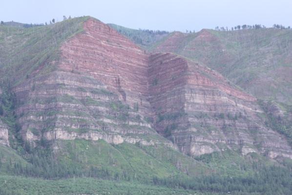
Figure 1. Red cliff sedimentary layers. Original photograph by the author
Consider, for instance, an assignment for which students compose a layered representation of their literacy processes. In such an assignment, students are taught to recognize and employ pictorial mapping techniques conveying a specific message in addition to revealing influential layers underneath the message. The Official Texas Brags Map of North America (Figure 2)[1] is one such example.
Figure 2. The Official Texas Brags Map of North America. Image courtesy of the David Rumsey Map Collection.
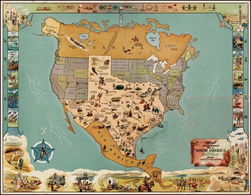
When I first saw this image (as wall-hanging art in a relative’s home), I was intrigued by the multiple layers of information conveyed through the map: information potentially identified as everyday embodied experiences. Viewers/readers of this map are certain to notice the hyperbolic size of Texas, and the bordered images representing natural resources, landmarks, and ethnic diversity (albeit problematic in their representations). The cartographic techniques highlighting particular characteristics and clearly communicating a specific message piqued my interest, and I began to think about ways to design assignments that foreground students’ lived experiences and thus foster critical attention to the multiple layers informing their writerly identities. To my mind, the communicative techniques in pictorial mapping, as evidenced in the Texas Brags map, potentially raise students’ awareness of the unintentional influencers upon their literacy acts.
In my experience, a large part of academic writing occurs outside of my classroom, yet students are unaware of these influences. Since these out-of-class experiences are mental and are associated with images “of place we carry around in our heads” (Reynolds 80), they become a student’s inner history. Students’ literacy acts are also influenced by the various lived experiences through which they travel and have traveled (Drew), yet students may not be fully aware of how those experiences shape their thinking. Compositions created by mapping techniques provide students the opportunity to visually represent their experiences. While the experiences occur in sequential layers, revealing them through the cartographic-type technique of the pictorial map allows for a non-linear or less sequential way of examination, which is what Murray calls non-discursivity. In fact, he argues that writing instructors must not only teach discursive forms of composition, but non-discursive forms as well; it is necessary for students to “become adept at ‘writing’ non-discursive texts with its layers, images, and… pervasive affectivity” (Murray 8), particularly if students are “ever to understand how image and the affective work together in rhetoric” (Murray 187). As a result, viewpoint maps, such as the ones described here, provide students the opportunity to consider the following: 1) the non-sequential layers of their lived experiences informing their literacy acts, and 2) a nuanced understanding of the connections between affect and image. As students become aware of these sedimentary, layered experiences, they are positioned to critically examine the layered life experiences shaping their literacies, and they have the opportunity to develop into empowered thinkers and writers.
Designing the Study
I was intrigued by the potential for an assignment that foregrounded ways students’ out-of-class lived experiences influenced their literacy practices. I therefore designed a study to ascertain the relevance of the assignment. The study was conducted in an R-1, public university in a south-central state.[2] The course was a second-semester first-year writing course, and students ranged from first-year students to seniors. There were seven students who consented to participate from two semesters of the IRB-approved study.
The study was guided by grounded theory to collect data, to see what might emerge, and to work to explain any phenomena. Data collected included 1) the viewpoint maps, 2) a recorded or written rationale explaining each student’s story/rationale of their map, 3) a semi-structured interview (see Appendix A), and 4) reflective memos from my teacher-research journal. During the semester, I kept “live journal” notes, where I noted students’ reactions and interactions in class. After each class, I went to a coffee shop and wrote memos to reflect on the “live journal” notes. Through theoretical sampling, as described by Birks and Mills,[3] I collected data from my research journal, and collected the viewpoint maps. Finally, I collected students’ stories about their viewpoint maps.
I adopted a cultural rhetoric approach (as defined by the Cultural Rhetorics Theory Lab in enculturation in 2016)[4] in my analysis as I examined the recorded rationale, the semi-structured interview data, and the viewpoint maps. What became the most interesting of the three data sets was the semi-structured interview, particularly when I realized that the data depicted a story of each student’s composing process. I spread the maps across the floor and started looking for similarities. These included students drawing themselves in the map, religious affiliations, civic organizations, and part-time jobs, among others. Each of the maps provided me, their instructor, with valuable insight into their identity as a student writer. I used this insight to guide my writing conversations and feedback and teaching illustrations during whole-class instruction. While all seven student-constructed viewpoint maps and subsequent student work are intriguing, I do not have the space here to fully examine and explain all of the data. Therefore, I have elected to present a case study and to explore one of the maps as representative of the much broader data set.
Assignment
Inspired by the aforementioned Texas Brags Map of North America, I designed an assignment asking students to thoughtfully consider places where they interact that impact their academic identity at their current institution. To introduce the semester-long course on the first day of class, I explained I wanted them to think about defining “composition” in a different way than perhaps they had done before. I guided them to think about composition as a layered combination of communicative modes (i.e., alphabetic text, image, sound, movement) working together for a specified purpose intended for a target audience. Students next brainstormed types of texts that visually depict traveling to places. After some discussion, they came to consensus that maps are such a text. The remainder of the first day was general information from the syllabus, and a “get-to-know-you” activity.
For the second day of class, I designed an ice-breaker activity asking students to think about the route they took to get to campus. I asked them to draw a map showing that route, with symbols representing particular buildings or places that stuck out in their memory, and they were given the opportunity to share their maps with two or three classmates. I wanted to begin the semester emphasizing the rhetorical nature of effective communication. I assigned a pre-class reading selection from one of the course texts (Understanding Rhetoric: A Graphic Guide to Writing). During class, students discussed in small groups how they might change their map for different audiences: grandparents, fellow students, or visiting high school students. We briefly discussed their thoughts, making note of any resulting communicative patterns (techniques used for all three audiences). We discussed strategies and techniques used by a mapmaker to convey meaning—techniques such as line variations, symbols, colors, borders. Students were encouraged to construct a list of these techniques in their notes for future reference.
On day three of the course, I introduced the more specialized form of mapping: pictorial mapping. I explained that pictorial maps are maps composed with more of an artistic flair than technical maps, and they are generally created to emphasize otherwise unknown details within a particular location. Together, we examined our first example of a pictorial map (Figure 3).
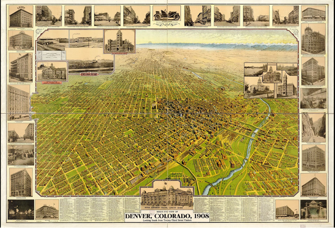
Figure 3. Bird’s eye view of Denver, Colorado, 1908.
I facilitated a discussion guiding students to consider how this map (obtained from the Library of Congress) was created to change early 1900s normed perceptions of Denver, Colorado (a city in the “wild” West). We noted, as Barton & Barton argue, the emphasized specific features designed to persuade outsiders toward a positive attitude about visiting the city and even leaving jobs and family in the East to relocate to the West and enjoy all the opportunities Denver had to offer. Pictorial maps provide ways to think about the information that is available for interpretation by both viewer and composer. Kress and van Leeuwen explain how the intentional position and arrangement of images and “framing devices” (177) work together to communicate specific meanings. In Figure 3, notice the images the map maker decided to include: large, modern (for the time) buildings; an automobile (perhaps to indicate travel accessibility); a bird’s-eye view of the gridded city (perhaps to indicate order and structure); and even nighttime images. Viewer attention is drawn to the neat, gridded layout of the city, the block pictures of modern buildings surrounding the perimeter as points of emphasis, and the name of the city and date of 1908. This image, along with another 4 or 5 pictorial maps of other cities (also collected from Wikimedia Commons), provided the foundation for the forthcoming assignment because the genre-specific features of pictorial maps are clearly displayed.
Following these images, I introduced my students on the fourth day of class to two final examples: the Texas Brags Map of North America (Figure 2) and a map from a cover of The New Yorker, the View of the World from 9th Avenue[5] pictorial map (Figure 4).
Figure 4. Saul Steinberg, View of the World from 9th Avenue. Cover of The New Yorker, March 29, 1976. Copyright The Saul Steinberg Foundation/Artists Rights Society (ARS), New York.
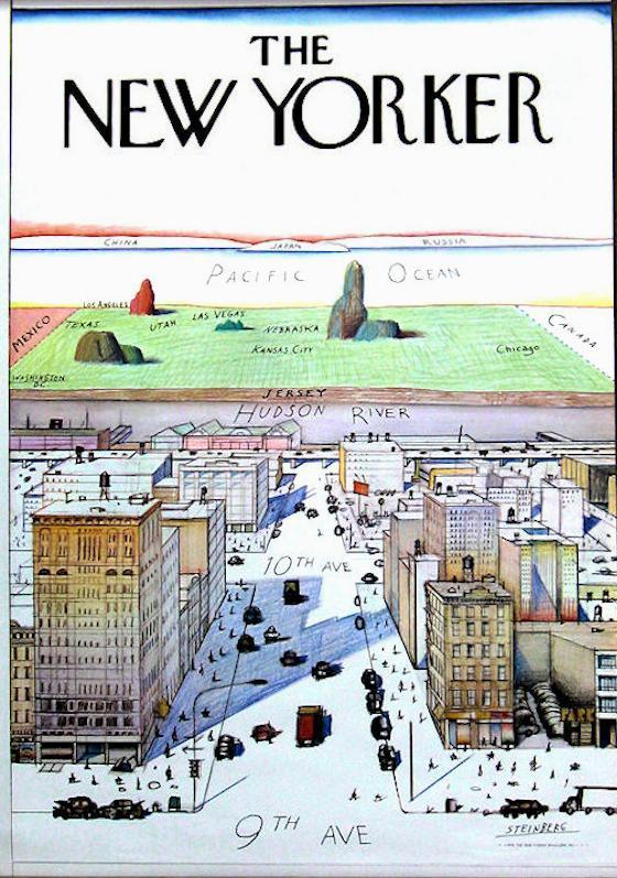
Adopting a genre-theory approach, I explained to students they can determine useful characteristics by examining several viewpoint maps and noting specific features shared by the maps. I guided a class discussion, for which we examined the common strategies for communicative purposes from the maps and constructed a list of the features. Again, I encouraged students to keep record of our class discussion in their notes. Common features and techniques we discussed were a bordered frame, a particular perspective, combination of image and text, the size of images indicating importance, the placement of images indicating prominence, and the use of color, to name a few. I next presented my students with the following assignment:
View of My Academic Identity @ My Institution:
- What outside-lived experiences influence my literacy acts?
- What experiences at my university do I think are important for my literacy growth?
- Where do I see myself fitting into the overall scope of this class? Of the academic life at my university?
Considering the above questions and drawing from the list of mapping techniques we’ve identified in class, compose your own Viewpoint Map depicting your identity as a student/scholar at this university.
The assignment asked students to consider four questions and respond with an original viewpoint map. My three goals for the above assignment were as follows: 1) for students to intentionally consider specific places they frequently inhabit; 2) to consider how those places inform their perception about how they identify as post-secondary students; and 3) how those places inform their thinking and writing. I encouraged them to refer to their list of genre-specific cartographic techniques used in pictorial maps (constructed during class discussion) as they took the upcoming week-end to construct their own viewpoint map of their academic identity.
The student for the case study was a white, cisgender male majoring in pre-law, with added interests in petroleum production, in his early to mid-‘20s. He was a senior, who, according to his introduction on the first day of class (teaching journal notes), had delayed taking this course for as long as possible. I am particularly interested in this student because he was so hesitant to take this class as part of his general education requirements, and his data exhibits interesting insight into the perspective map assignment as it impacted his perceived writerly identity. Figure 5 is the example of Rob’s (pseudonym) response.
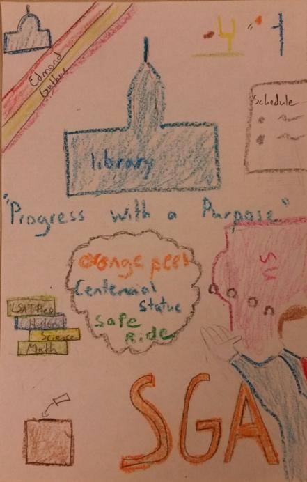
Figure 5. Student Viewpoint Map.
In Rob’s viewpoint map, the student drew the school library and placed it in the upper center. Running across the very middle of the composition is the slogan “Progress with a Purpose,” and (starting at the lower left-hand corner, moving clockwise) there are images of a podium with a microphone, stacked books, the state capitol building lying beyond two nearby cities, a football and goal, a class schedule, the Student Union, and a thought-bubble connected to a self-portrait right next to “SGA” (an acronym for Student Government Association). Absences in the viewpoint map are also noteworthy; other than the small-by-comparison football and goal image, there is no image of the very large football stadium visible from many points across campus. There also are no other athletic arenas (baseball, softball, tennis, soccer,); there is no mention of Greek Life or specific classroom buildings.
Thinking about this viewpoint map in philosopher Susanne K. Langer’s terms of denotation and connotation[6] is what moves the student’s composition beyond mere picture. Denotation helps me identify the distinct images. For example, when I examine this composition denotatively, I notice specific representations: the library, the student union, the partial self-figure, and so on. Visual rhetoric grammar aids me when I examine the composition connotatively. I notice the position of each image and draw conclusions based on the size and the position of the image. This analysis is broadened by the data from the student’s recorded rationale and from my reflection journal notes during the semi-structured interview, which I elaborate on below.
The inclusions and absences of images provide salient points for me, the instructor, to consider when I conducted writing conferences with this student because rather than creating and using analogies based on sports, I would explain concepts in terms of political activities. During one conference, the student did not clearly understand how to distinguish a target audience from a general one. I explained, drawing from the student’s experience of being an intern at the State Capitol, how passing a bill through a committee distinguishes between “target” and “general” audience. Having the student’s viewpoint map gave me immediate access to the layered lived experiences important to him and his literacy growth, and thus influenced my pedagogical approaches.
I followed up with this student by asking him to explain his design choices (to tell his story) in a recorded rationale. He stated the library was in the center because it was where he spent most of his time, and his stack of books indicated his preparation for the upcoming LSAT examination. He was involved in student government, hence the large “SGA” letters in the lower, right-hand corner, with mention of a campaign slogan for “progress” and SGA’s “safe-ride” project motto. Finally, the student drew himself waving (lower right-hand corner)—indicating the way he saw himself interacting “then and again” (recorded rationale) during class discussions. After Rob provided his rationale, we met for the semi-structured interview.
An intriguing moment in the interview was when the student explained his decisions for arranging and sizing of each image to represent the level of priority the location has in his experiential knowledge. The Student Union was an important place for him (his involvement with student government), and that tended to influence his interpretations of course material and his interactions within each class he attended. His knowledge of government policies helped him offer different perspectives during class discussions. I notice from my reflection journal notes that during one class discussion, when students were discussing “context” in terms of the rhetorical situation, Rob, after a few moments of listening to students, suggested that when political candidates prepared their speeches for garnering support, the speech-writer’s job was to research the community—including churches, the size of the school and its test scores, businesses, and so on—and to combine all this information into a context analysis report, which was used to compose a speech that effectively targeted the community voters.
Rob’s student government experiences also influenced his writing because his texts—no matter what course he attended—usually contained a political analogy used to help him argue for his point (interview). In a course assignment asking students to choose a scholarly, research-based article, conduct a close reading, and then identify and explain their reading strategies, this student chose a legal research article about Uber. For him to explain his academic reading strategies, he chose an article explaining a court case and subsequent judicial ruling that impacted Uber’s policies and practices. This textual data supports my analysis of his viewpoint map, from which I suspected the student had a large interest in legal issues (the stack of books labeled “LSAT” and the “SGA”). For Rob, the viewpoint map provided him viewable information about his otherwise unconscious lived experiences that impacted his relation to course assignments and texts. The images in the map provided me and him with layered nuances through which we were able to connect during writing conferences, thereby allowing me the opportunity to guide his academic growth. In short, this student’s embodied experiential layers influenced his academic literacy.
Another important take-away from the student’s rationale was when he explained his partial self-image represented how he saw himself fitting into the class. Thinking of students in the way Julie Drew describes them as “travelers” whose literacy acts are continually influenced by their navigation through their lived experiences, this student’s response provided me with interesting insight into his literacy acts. I noticed throughout the entire semester, Rob rarely spoke first when I conducted whole-class discussion; he waited for others to speak, then offered either support or asked for additional clarification of an idea before responding to the discussion prompt. His compositions contained evidence of his thoughtful engagement with assigned course readings and class discussions. He readily interacted with communication and persuasion materials, which aligns with his obvious goal of pursuing a career in law and/or politics.
In a commitment to guide students toward hearing their own voice (as Jacqueline Jones-Royster encouraged us to do in 1996) rather than a voice unduly influenced by systemic power structures and hegemonic narratives (Anzaldúa; Cushman; Garza-Falcón; hooks; Inoue), this student’s data suggests his growing awareness of identity and agency in the midst of his academic career. According to my teaching journal notes, during the one-on-one conversation mentioned earlier, the student became pensive when I asked him to reflect on his decision to prominently position his involvement in SGA and explain how his literacy practices were influenced by this organization. He admitted his responses to assignments—particularly writing assignments—were largely influenced by his experience in the student government. The connections between his lived experiences and his assignment responses were not something he had realized before. For example, he always responded with critical attention to his audience. He explained that before creating his viewpoint map, he was not consciously aware that his attention to audience was influenced by his work in politics nor that a speaker must identify with the audience in order to be effective. His writing processes were also impacted because he began every assignment with two aims in mind: 1) his audience; and 2) the best way to convey his message to that audience. Interestingly, he also mentioned in one of our one-on-one writing conferences that the maps had, in fact, helped him identify with peers in the class since he, after a class showcase, learned information about his peers that he used as conversation-starters during peer review and other in-class activities.
This assignment potentially fosters students’ awareness that writing is a reflexive activity because there is increased opportunity for students to interrogate the revealing and concealing of place on their perspective maps. Students thoughtfully explore the out-of-class experiences informing their notions about literacy, thus potentially strengthening writer agency. I am not meaning to make a grand claim here about the perspective/pictorial map assignment. I am, however, interested to note that Rob became critically aware of the ways his embodied experiences influenced his literacy acts. Rob’s map provided specific experiences from which I could draw to guide his literacy growth.
When students become aware of the layers within the viewpoint map (layers as indicated by the size of images in the above example), they have an additional opportunity to reflect on their thinking processes and the embodied experiences that influence their writing. Kristie Fleckenstein argues student agency—“the element most vital to social change”—emerges when instructors guide students toward meaningful understanding of the interplay between “visual and rhetorical habits transacting in specific places” (Vision 18). We know it has always been the goal in rhetoric studies to tend the rhetorical situation, which, among other elements, considers “the place in which the issue merits attention” (Crowley and Hawhee 37). Recalling Shor’s student empowerment and Farmer’s citizen bricoleurs, cartographic techniques allow instructors to design assignments fostering critical self-reflecting. Through this assignment, my student realized the connections between place and literacy practices. He was able to think about those connections and consider potential readjustments or changes for him to more effectively communicate his intended message to his target audience.
Limits to the Study
While I realize I have discussed Rob’s map in a positive light, I want to acknowledge issues that may emerge from this type of assignment and the pedagogical strategies I use to work against potential problematic aspects. Some instructors may worry that students’ revealed layers will not be empowering—or even harmful should students feel compelled to remember a hurtful experience. At the point of this writing, I have witnessed only positive reactions when students explain symbols on their viewpoint maps. Since students are able to choose which places to depict, I remind them that they maintain control of the map’s design. Another potential challenge is that students may not have positive campus experiences and therefore will be uncomfortable drawing those places. The assignment I have described here may influence students to draw only campus places, so I continue to revise the assignment to encourage students to draw a symbolic map depicting who they are as an academic. Many students draw campus locations, but a growing number of students draw off-campus and out-of-state places and experiences. Finally, the teacher-student power dynamic can unduly influence student maps, so although we discuss the example viewpoint maps and the assignment in class, students have several days (over the course of a weekend, in fact) to construct their maps. Some maps are more detailed than others, and many do not contain any institutional buildings. A more thorough comparison of the five semesters of data, however, lies beyond the scope of this article, but it is noteworthy that allowing students to construct their maps away from my immediate attention seems to foster individual creativity and expression.
I want to be clear that I am not claiming this is the only assignment that will accomplish what I am advocating for in writing instruction. My aim in this essay, though, is to provide an impetus that spurs pedagogical creativity and innovation to design assignments useful for critical examination of the interconnectedness between place and writing. When we recognize place informs identity (Anzaldúa; Garza-Falcón) and believe writing as evidence of “an embodied interaction with other beings and our environments” (Cooper 18), we understand that writing is “a complex system” (Cooper 20). We also understand it is “a set of spatial practices informed by everyday negotiations of space” (Reynolds 6). If we accept the call for writing instructors to not only understand how students enter classrooms with out-of-class lived experiences (Drew), but to also understand the ways “their embodied practices” (Reynolds 175) and environmental forces influence writing processes and meaning-making (Rule), then it follows we need a method to reveal the invisible layers for critical examination. I encourage writing instructors to interrogate writing places and the resulting influences on literacy practices as well as explore cartographic techniques’ potential to visualize the influence of place. In sum, it is important to consider not only the connections between place and writing but also to consider a method visually representing those connections.
Conclusion
I began by extending Cooper’s assertion about writing and Cresswell’s social geographies to complicate traditional uses and interpretations of maps, thus providing a nuanced understanding of maps. I also drew from Murray to re-imagine maps as non-discursive and profitable for pedagogical practice. Maps, while constructed by standardized symbols, lines, and colors, convey meaning beyond the grid lines and color-codes. This understanding fits Cresswell’s discussion regarding place as meaningful because maps, as Wood contends, are the creations of people’s “social relations” (Rethinking 19); they communicate the multiple layers of identity informing place.[7] Further, the meaningful interactions by which we identify place are symbolically represented and thus realize the social relationships that inform literacies.
Writing is a complex activity with multiple influencers and influences, and I contend mapping technology presents useful strategies to examine these phenomena—so that what is invisible is made visible. Possibilities await us in writing instruction when, as Rule argues, “Focusing upon embodied interaction with immediate material environments… illustrates… how processes are susceptible to environmental forces and never in writers’ full and autonomous control” (405). Through cartographic compositions such as viewpoint maps, environmental forces can be realized and transferred from abstract notions into concrete data. Visually representing the locations of social practice transforms space into identifiable place. Instructors can guide students to visually depict their embodied experiences, which allows them the opportunity to interrogate their expectations about composing practices and thus interrogate ideologies. This type of visualization potentially encourages critical awareness of literacy practices. Such visibility provides opportunities for us to “broaden [our] senses of the text” (Wysocki 7), to foreground day-to-day experiences informing literacy acts.
For future study, we can also appreciate an important communicative strategy emerging in cartographic literacy known as “Counter-mapping” (Cresswell; Wood, Rethinking). Counter-mapping takes, as Wood argues, mapmaking in an interesting direction, because composers create Protest Maps and/or Critical Maps, to communicate resistance to hegemonic ideologies. There is potential in future research to examine how students might be encouraged to interrogate power structures within their embodied experiences and literacy acts, thereby becoming empowered advocates for social justice, which will continue and strengthen our critical pedagogy heritage.
This, then, is the value of map technology in a composition classroom: through various uses of maps, instructors are able to raise students’ critical awareness of place as it informs literacy. We can consider the interplay between the multiple contexts we travel in and through each day, and interpret those experiences to stimulate mental images of meaning-making within the place. The way we operate in our lived places informs our ability to draw “unexpected results from [our] situation[s]” (de Certeau 30), as in the case of the social relationships formed through the travel experiences, when travelers mark favorite stopping points or restaurants. Through our experiences in locations, our perceptions about any specific place may change or may be enhanced. Cartographic mapping techniques allows composers and readers alike to visually represent and understand these social relationships because the maps provide visual symbolizations of the invisible experiences occurring through space.
The writing classroom is rich with opportunities to explore and critically examine inner histories. Though we encourage students to find their own voice and to gain a sense of who they are as writers, it is also important for us to guide students to probe layers underneath manifested literacy acts because that provides opportunities for instructors to practice critical pedagogy as they guide students to consider power relations (Freire; Shor), and to develop agency (Anzaldúa; Fleckenstein, Vision; Garza-Falcón), and examine our own pedagogical practices (Inoue). The temporal, sequential layers of lived experiences seem to impact students’ literacies in nuanced, perhaps even messy, ways. When writing instructors encourage students to construct a spatial, non-sequential (i.e., non-discursive) representation of those experiences, they afford students the opportunity to interrogate experiences in terms of importance or prominence rather than recent to past.
It is my goal here to demonstrate the potential mapping technology has for writing pedagogical contexts, to explore the nuanced possibilities mapping technologies afford students to examine the layered phenomena of their inner histories—so that what is invisible is made visible, and thus available for critical interrogation. Critical pedagogy’s established history calls writing instructors to foster opportunities for students to examine their inner histories in order to determine ways their literacy acts can change and develop so that societal change is made possible (Giroux 150). The “what” we need to do is clear, but it is the “how” where there remains room for continual exploration. My aim is that this essay contributes to this growing body of knowledge. Through cartographic techniques, we provide innovative ways to guide our students toward deeper awareness of the complicated layers informing their literacy acts. Once aware, students can then effectively interrogate their literacy practices and, perhaps, adjust themselves as citizen thinkers and writers. Our students can write from a place where they emerge as empowered writers with strengthened writerly identities who seek a more equitable and just society.
Appendix A: Semi-Structured Interview Guide
1. What connection do you think exists between your physical position in the classroom and your performance on class assignments?
2. Please explain which class interactions are most beneficial to you for you to be successful on class work (i.e. work with small groups, work with a partner, work with course instructor, etc.):
3. Please describe a specific instance where you were most productively engaged in the class work:
4. Please explain your reaction at the beginning of the course when you were informed about the multimodal nature of this course:
5. In what ways did the multimodal approach and assignments have an impact on your literacy growth?
Notes
[1] Image used with permission from the David Rumsey Collection at Stanford University: unable to contact original publisher and cartographer (John Randolph and Mark Storm, 1948).
[2] According to the university website, there is a 20.1 student-to-faculty ratio, 26% of the student population are out-of-state, and international students represent 100+ countries.
[3] “Theoretical sampling” is “the process of identifying and pursuing clues that arise during analysis in a grounded theory study” (Birks and Mills181). See Grounded Theory: A Practical Guide, 2nd edition for a thorough discussion of this research method.
[4] “Cultural rhetorics,” according to the Cultural Rhetorics Theory Lab, is an approach that considers context to be integral to the interpretation of thinking and writing. It allows me to examine ways “complex layers interact within themselves and within the writer to inform knowledge meaning and making” (Canfield 21).
[5] Cover reprinted with paid permission from The Saul Steinberg Foundation/Artists Rights Society. All rights reserved. Copyright The Saul Steinberg Foundation/Artists Rights Society (ARS), New York.
[6] Langer fully discusses her theory in Philosophy in a New Key. “Denotation” and “connotation” are two important characteristics of symbolization for Langer’s argument that signs and symbols are integral to the meaning of any item.
[7] Of particular interest is the example Wood (Rethinking) describes when mapping practices “played an essential role in the creation of the Territory of Nunavut” (111). Following this link to an encyclopedia article (https://www.britannica.com/place/Nunavut) reveals an interesting account where we learn that through mapping a territory, an indigenous people group gained national identity. It was, in fact, a case where counter-mapping represented a persuasive message identifying an otherwise marginalized group and providing them a sense of being by revealing their relationship to the material, to one another, and to the rest of the world. Rather than accepting the identity imposed upon them, the Nunavut people used the language and technology of cartography to assert their unique identity, thus gaining agency.
Works Cited
Anzaldúa, Gloria. Borderland/La Frontera: La Mestiza. 4th edition, Aunt Lute Books, 2012.
Barton, Ben F. and Marthalee S. Barton. Ideology and the Map: Toward a Postmodern Visual Design Practice. Central Works in Technical Communication, edited by Johndan Johnson-Eilola and Stuart A. Selber, Oxford UP, 2004, pp. 232–52.
Birdseye View Publishing Co.; Denver Lith Co. Bird’s eye view of Denver, Colorado, 1908. Library of Congress, 2015, https://www.loc.gov/item/75693133/. Accessed 15 Feb. 2018.
Birks, Melanie, and Jane Mills. Grounded Theory: A Practical Guide. 2nd edition, SAGE, 2015.
Canfield, Jeaneen S. Miller. (Re)Imagining Cartographic Techniques in Writing Pedagogy. Oklahoma State U, PhD dissertation.
Certeau, Michel de. The Practice of Everyday Life. Translated by Steven F. Rendall, U of California Press, 1984.
Cooper, Marilyn. Being Linked to the Matrix: Biology, Technology, and Writing. Rhetorics and Technologies: New Directions in Writing and Communication, edited by Stuart A. Selber, U of South Carolina P, 2010, pp. 15–32.
Cresswell, Tim. Geographic Thought. John Wiley & Sons, 2013.
———. Place: An Introduction. 2nd edition, John Wiley & Sons, 2015.
Crowley, Sharon, and Debra Hawhee. Ancient Rhetorics for Contemporary Students. 5th edition, Pearson, 2012.
Cultural Rhetorics Theory Lab (Malea Powell, Daisy Levy, Andrea Riley-Mukavetz, Marilee Brooks-Gillies, Maria Novotny, Jennifer Fisch-Ferguson). Our Story Begins Here: Constellating Cultural Rhetorics Practices. enculturation: a journal of rhetoric, writing, and culture, vol. 18, 2014, http://enculturation.net/our-story-begins-here.
Cushman, Ellen. Translingual and Decolonial Approaches to Meaning Making. College English, vol. 78, no. 3, 2016. pp. 234–42.
Drew, Julie. The Politics of Place: Student Travelers and Pedagogical Maps. Ecocomposition: Theoretical and Pedagogical Approaches, edited by Christian R. Weisser and Sidney I. Dobrin, State U of New York P, 2001, pp. 57–68.
Farmer, Frank. After the Public Turn: Composition, Counterpublics, and the Citizen Bricoleur. Utah State UP, 2013.
Fleckenstein, Kristie S. Embodied Literacies: Imageword and a Poetics of Teaching. Southern Illinois UP, 2003.
———. Vision, Rhetoric, and Social Action in the Composition Classroom. Southern Illinois UP, 2010.
Freire, Paulo. Pedagogy of the Oppressed. Continuum, 1970.
Garza-Falcón, Leticia M. Gente Decente: A Borderlands Response to the Rhetoric of Dominance. U of Texas P, 1998.
Giroux, Henry A. Theory and Resistance in Education: Towards a Pedagogy for the Opposition. Bergin & Garvey, 2001.
hooks, bell. Teaching to Transgress: Education as the Practice of Freedom. Routledge, 1994.
Inoue, Asao B. Antiracist Writing Assessment Ecologies: Teaching and Assessing Writing for a Socially Just Future. Parlor P, 2015.
Kress, Gunther, and Theodore van Leeuwen. Reading Images: The Grammar of Visual Design. 2nd edition, Routledge, 2006.
Langer, Susanne K. Philosophy in a New Key. Harvard UP, 1957.
Losh, Eizabeth, et al. Understanding Rhetoric: A Graphic Guide to Writing. 2nd edition, Bedford/St. Martin’s, 2017.
Murray, Joddy. Non-Discursive Rhetoric: Image and Affect in Multimodal Composition. State U of New York P, 2009.
Prior, Paul, and Jody Shipka. Chronotopic Lamination: Tracing the Contours of Literate Activity. Writing Selves: Writing Societies, edited by Charles Bazerman & David R. Russell, WAC Clearinghouse, U of Colorado P, 2003, pp. 180–238.
Randolph, John, and Mark Storm. Official Texas Brags Map of North America. The David Rumsey Collection. 1948. Retrieved with written permission from https://www.davidrumsey.com/luna/servlet/detail/RUMSEY~8~1~271546~90045417:Official-Texas-Brags-Map-of-North-A.
Rea, Kenneth John. Nunavut Territory, Canada. Encyclopedia Britannica. https://www.britannica.com/place/Nunavut. Accessed 20 Aug. 2017.
Reynolds, Nedra. Geographies of Writing: Inhabiting Places and Encountering Difference. Southern Illinois UP, 2004.
Royster, Jacqueline Jones. When the First Voice you Hear is not Your Own. College Composition and Communication, vol. 47, no. 1, 1996, pp. 29–40.
Rule, Hannah J. Situating Writing Processes. WAC Clearinghouse, U of Colorado P, 2019.
———. Writing’s Rooms. College Composition & Communication, vol. 69, no. 3, 2018, pp. 402–32.
Steinberg, Saul. View of the World from 9th Avenue. Cover of The New Yorker, 29. Mar. 1976. Cover reprinted with permission of The New Yorker magazine. All rights reserved. Copyright The Saul Steinberg Foundation/Artists Rights Society (ARS), New York. https://saulsteinbergfoundation.org/ Accessed 2 Nov. 2018.
Shipka, Jody. Toward a Composition Made Whole. U of Pittsburgh P, 2011.
Shor, Ira. When Students Have Power: Negotiating Authority in a Critical Pedagogy. U of Chicago P, 1996.
Short, John R. Making Space: Revisioning the World, 1475–1600. Syracuse UP, 2004.
Wood, Denis. The Power of Maps. Guilford P, 1992.
———. Rethinking the Power of Maps. Guilford P, 2010.
Wysocki, Anne. Introduction: Into Between—On Composition in Mediation. composing(media) = composing(embodiment): bodies, technologies, writing, the teaching of writing, edited by Kristin L. Arola and Anne Frances Wysocki, pp. 1–22. U of Colorado P, 2012.